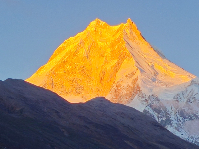
The ‘Manaslu region’ is also known as the Manaslu Conservation Area. It covers a 1663 km2 area in the northern Gorkha district of Nepal and was declared a conservation area in 1998. It offers visitors a glimpse of pristine natural and cultural traditions. It has beautiful scenery of the majestic Himalayan ranges, including Manaslu I (8163m)—the eighth-highest peak in the world.
Other attractions are high-altitude glacier Lakes and Buddhist monasteries. Ecologically, MCA has a diverse range of habitats that support rare flora and fauna, including snow leopard, lynx, musk deer, red fox, jackal, and brown bear, as well as their prey species, such as blue sheep, Himalayan Thar, Himalayan serow, and Himalayan marmot. It is also home to various birds, including the snow partridge, the Tibetan Snowcock, the Himalayan griffon, and the golden eagle, as well as diverse plant communities.
How to get there: A day bus journey takes you from Kathmandu to Machha Khola, Gorkha. The walk begins here through the Budhi Gandaki valley before crossing the Larkya La (5160m) mountain pass and descending to Dharapani in the Manang district. We offer a multi-day trek in the Manaslu region. Take a look!
| MCA FACT SHEET: | ||
| MCA declared: | 1998. | |
| Total Area: | 1663sq. km. | |
| Major Ethnic Group: | Chhetri, Braman, Mangar, Gurung, and Tibetan. | |
| The highest peak: | Manaslu I (8163m). | |
| Major Destinations: | Chhokang Paro, Mu Gomba, Sama Gaon, Pengyen Gomba, Manaslu Base Camp, and Samdo village. | |
| Trekking to the highest elevation: | Larkya La 5160m pass. | |
| Lakes: | Kal Tal, Birendra Tal, and Ponkar Tal. | |
| Bio Climatic zone: | Sub-tropical to Nival. | |
| Economy: | Agriculture, Animal Husbandry, Seasonal Migration (Trade and Labour), Tourism, and Service in the Army. | |
| Plants: | 2000. | |
| Mammals: | 39. | |
| Birds: | 201. | |
| Reptiles: | 3. | |
| Butterflies: | 11. | |
Step onto the legendary Manaslu Circuit Trek, where ancient Himalayan trails await. This route immerses you in authentic Nepali and Tibetan culture, renowned hospitality, and spectacular views of the Manaslu, Ganesh Himal, Sringi Himal, and Annapurna ranges. From culture to mountain vistas to physical fitness, it offers trekkers everything they might want from a Himalayan […]
view details